When a certain group of species is at the risk of being endangered, it is important for wildlife conservatories and organizations to keep track of how many are left. It is also important to keep animals that are endangered from the risk of being assaulted or killed by poachers.
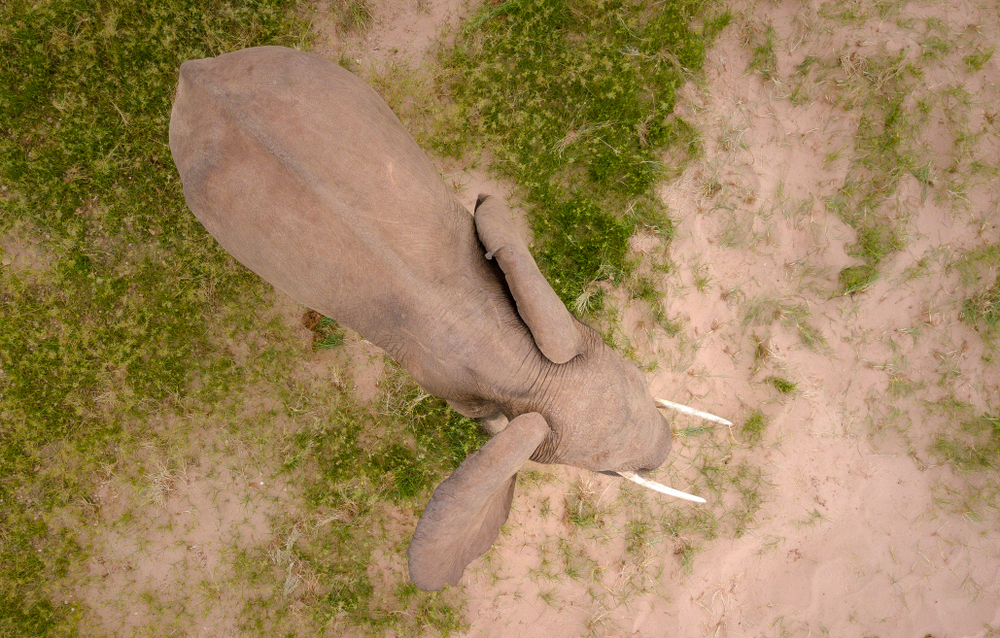
Elephants are one of the species that are still at risk of becoming endangered. Over the course of the years that have gone by, the population numbers of the species have decreased to over 50%. This is mainly because the current methods of protecting these species could lead to different errors such as number errors on populations and wrongly moving resources.
To solve this issue and improve the methods of tracking Elephants. A team of scientists from the University of Bath, the University of Oxford, and the University of Twente in the Netherlands, came together and created a satellite to track the elephants from space. The satellite the scientists used called the Maxar WorldView-3 satellite imagery. It is a satellite that is able to collect imagery of more than 100 million acres in a matter of seconds.
Another thing that is great about the satellite is that it is able to double the risk of error since the images are coming at the trackers in a matter of seconds. After utilizing the satellite, the scientists then used the process of deep learning to analyze the many images that were collected from the Maxar WorldView-3 satellite. Within a matter of hours, the team of scientists was able to collect and gather the data that was relevant to their study. Typically, it would take many months when a team does it by hand. It’s amazing how it was done in a matter of seconds.
Besides the capability of taking rapid images in a matter of seconds, the satellite has deep learning algorithms. This provided results that were deemed consistent and made errors less likely to occur. The algorithms did also include false negatives and false positives.
The team of scientists made this happen by creating a method. They made a training dataset of 1,000+ elephants. They then fed the dataset into a Convolutional Neural Network which is also known as CNN. After countless trials, the team made the conclusion that their CNN can spot elephants with satellite imagery with the same capabilities of detecting humans.
According to Dr. Olga Isupova, a computer scientist from the University of Bath, she had said that over the years, the resolution of Satelite Imagery continues to increase. And with every increase, people are able to see more things. She also said that there are other researchers now who can detect Black Albatross from the white snow. It is true that satellites can now differ from black and white but the fact that the Albatross nest is 1/11 inch of an elephant, now that’s something that proves satellite imagery has evolved over the years.
About University of Bath
The University of Bath is a public research university that is located in Bath, UK. The university received its royal charter in 1966 and also a number of institutions. The public research university is known for Accounting and Finance, Italian and Politics, and Mechanical Engineering.
About the University of Twente in the Netherlands
The University of Twente is a public technical university located in Enschede, Netherlands. The University is known for collaborating with Delft University and Technology and the Eindhoven University of Tech. The university is known for Advanced Tech, Civil Engineering, Electrical Engineering, and Mechanical Engineering.
About the University of Oxford
The University of Oxford is a research university in Oxford, England. The University has been around ever since 1096 as proven by the evidence or scriptures and teachings. The University is known for being the oldest university in the English-speaking world. The known majors at the university are Philosophy and Theology, Geography, Fine Arts, English Language, and Chemistry.